Take a walk on the GeoTrail
Next time you head to a state park, make sure you have your smartphone handy.
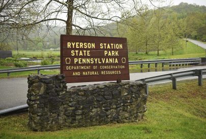
Twenty-five state parks, including Ohiopyle and Ryerson Station, have secret caches that will reveal stories about Pennsylvania’s history.
“Pennsylvania’s story lives in its landscapes — in the places where people worked, played, and helped shape the nation,” Cassandra Coleman, executive director, America250PA, said in a release.
The GeoTrail includes parks all over the state.
The technology-driven scavenger hunt, called geocaching, requires GPS coordinates from the website of the state Department of Conservation and Natural Resources.
Participants enter the coordinates into a smartphone or other GPS-enabled device and follow the directions to a hidden container (called a cache) that reveals a piece of park-specific history.
At Ohiopyle State Park, the theme is Washington’s raft, presumably a reference to George Washington and others building a raft to try and float down the Youghiogheny. That geocache is accessible to those with disabilities, according to a release from the DCNR.
The theme at Ryerson Station in Graysville, Greene County, is listed as “dangers of frontier life.”
The Whiskey Rebellion, rooted in Washington County’s history, is the theme at Point State Park in Pittsburgh.
The GeoTrial is among thousands of activities and events across the country that recognize America’s 250th anniversary.
DCNR Secretary Cindy Adams Dunn said, “Through initiatives like the DCNR America250PA GeoTrail, we are creating new opportunities for Pennsylvanians to connect with the places that shaped our nation.”
A link to more information about the GeoTrail, which will remain active through March 2028, is available in the news section of the DCNR’s website, https://www.pa.gov/agencies/dcnr.
Those who find the caches at all 25 parks can receive a completion coin.